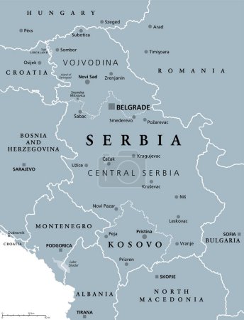
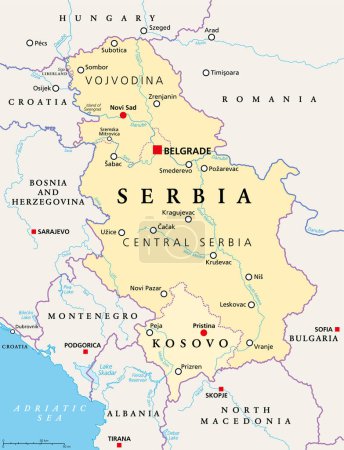
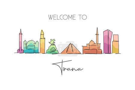
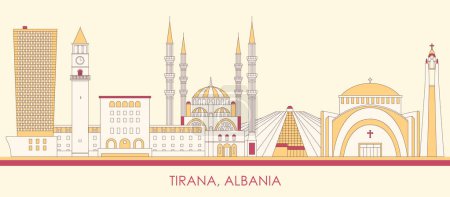
42 Vektoren zum Thema "capital of albania" bei ClipDealer

Medien sortieren nach     Gehe zu Seite:    
« Vorherige  1  Nächste »
European Capitals - Icon Set (Part 5)
Albania Welcome To Word Text with Handwritten Font and Golden Texture Design Illustration Vector.
Flags and countries
Tirana Solid Vector Illustration
Famous buildings of Tirana, Albania Composition. Hand-drawn black and white vector illustration. Grouped and movable objects.
Tirana Albania Colored Panorama
Puglia regional flag, italy
Tirana, Albania Famous Skyline Sketch
Tirana, Albania
Human country name Albania. large group of people form to create country name Albania. vector illustration.
Greece map
One continuous line drawing of Tirana city skyline, Albania. Beautiful landmark. World landscape tourism and travel vacation poster. Editable stylish stroke single line draw design vector illustration
North Macedonia political map with capital Skopje, borders, important cities, rivers and lakes. Former Yugoslav Republic of Macedonia, renamed in February 2019. English labeling. Illustration. Vector.
Cartoon Skyline panorama of city of Tirana, Albania - vector illustration
Single continuous line drawing of Tirana city skyline, Albania. Famous city scraper landscape. World travel concept wall decor home art poster print. Modern one line draw design vector illustration
One single line drawing of city Tirana skyline, Albania. Historical town landscape in the world. Best holiday destination poster. Editable stroke trendy continuous line draw design vector illustration
Europe Political Map and Roads
Albania cities stamps set
Mediterranean sea Map - Info Graphic Vector Illustration
Europe map cities
Macedonia Political Map
Albania country map polygonal with spot lights places
Europe Map - Vector Illustration
Macedonia region, political map. Region of the Balkan Peninsula in Southeast Europe. Part of Greece, North Macedonia, Bulgaria, Albania, Kosovo and Serbia. English labeling. Illustration. Vector.
Infographic for Albania, detailed map of Albania with flag.
Central Balkan Map - Vector Illustration
Corfu, island of Greece, gray political map. Also Kerkyra, is a Greek island in the Ionian Sea, and part of the Ionian Islands. With Othonoi, Ereikoussa and Mathraki it forms the Corfu Regional Unit.
Greece island Corfu map vector line contour silhouette illustration isolated on black background. Greek paradise island.
Greece, the Hellenic Republic, political map. Country in Southeast Europe on the southern tip of the Balkan peninsula, with capital Athens. Bordered by the Aegean, Ionian, and the Mediterranean Sea.
Isometric 3D Albania map,  vector illustration with cities, borders, capital, administrative divisions and pointer marks; gradient blue background.  Concept for infographic.
Central Balkan Map - Vintage Vector Illustration
Serbia and Kosovo, landlocked countries in Southeast Europe, political map. The Republic of Serbia, with capital Belgrade, and Republic of Kosovo, partially recognized country, with capital Pristina.
Serbia and Kosovo, landlocked countries in Southeast Europe, gray political map. Republic of Serbia, with capital Belgrade, and Republic of Kosovo, partially recognized country, with capital Pristina.
Greece, the Hellenic Republic, gray political map. Country in Southeast Europe on southern tip of the Balkan peninsula, with capital Athens. Bordered by the Aegean, Ionian, and the Mediterranean Sea.
Albania map in modern style with flag of Albania on left side.
Albania - detailed map with administrative divisions country. Vector illustration
Kosovo Political Map
Central Balkan Map - Vector Illustration
Greece island Corfu map vector line contour silhouette illustration isolated on blue background. Greek paradise island.
Geographical region of Macedonia, political map. Region of the Balkan Peninsula in Southeast Europe, part of Greece, North Macedonia, Bulgaria, Albania, Kosovo and Serbia. Illustration. Vector.
Albania dotted map flag with grunge texture in mosaic dot style. Abstract pixel vector illustration of a country map with halftone effect for infographic.
Aegean Sea region with Aegean Islands, political map. An elongated embayment of the Mediterranean Sea, located between Europe and Asia, and between the Balkans and Anatolia, Greece and Turkey. Vector.

« Vorherige  1  Nächste »